Introduction Wednesday, 17 August 2022, Cezar YO8TLC told us that a picoballoon (0x17) launched from France by Stefan DK3SB might have landed somewhere in northern Romania, relatively close to us. Cezar gave us all the info available and judging by the telemetry data the balloon landed in a mountainous region 65 kilometers away from our city, at an altitude of around 1000 meters. After crashing, the balloon seemed to continue to transmit telemetry data. In the following days, somewhat reluctantly, we tried locating it - without success. This is the report and how we did it. Resources:1. Grid Square SHP - A collection of all QTH grid squares in shapefile (SHP) format, as used by QGIS or ArcGIS https://sourceforge.net/projects/maidenheadshpfi/ 2. Digital Elevation Model - A collection of digital elevation model files (DEM) for GIS https://earthexplorer.usgs.gov/ 3. Quantum GIS - A highly capable GIS software, great for map creation and spatial data analysis - https://www.qgis.org/en/site/ All these resources are completely free and extremely useful! Creating the maps Once the telemetry data was analyzed we realized that the balloon crashed somewhere in KN27qp. Because of the low location accuracy reported by the system we had to take the entire grid square into consideration. Then we looked at the reported altitude, which had an accuracy of 100 meters and was reported for several days after the crash, at 998 m. I've found the QTH grid squares in shapefile format and imported them into QGIS. In order to get the terrain information inside the KN27qp and the surrounding area I used USGS Earth Explorer from which I downloaded the Digital Elevation Model on top of which I built the maps. The DEM allowed me to extract the contours and thus get the elevation in any given point. Applying some QGIS basic functions I separated an altitude range between 950 to 1050 meters (+/- 50 meters of the balloon's reported altitude) and exported the maps in raster format, along with the KML and GPS files that would later enable us to track our movement in real time. Listening for the WSPR We have decided to give it a try on Saturday, almost a week after the crash. We had no equipment ready at hand and so we had to improvise. Andrei YO8SSQ came up with the idea of using a SDR dongle connected to our phones. Unfortunately, the dongle he managed to find was crashing our phones a lot and was not on the right frequency anyway, so we asked Cezar YO8TLC for help. He couldn't come along for the ride, but gave us his SDR dongle and antenna. After a few hours of scrambling about, looking for long lost equipment and buying replacements (an OTG cable), we set out for Breaza on our motorbikes. In Breaza we stopped to scan for a signal. We connected the SDR dongle to our phones and used the SDR++ app with minimal results. The app crashed often and stopped detecting the dongle, requiring several reboots. There was a signal, but it faded in and out and we couldn't say for sure whether it was the balloon or not. Most probably not. We couldn't decode it and so we relied on the transmitting pattern of the payload (TX bursts of 110 seconds with a 10 second gap in between), but unfortunately it was too faint to pin it. On our two next stops there was total silence. The last spot might have been the better of the three, being on a hill, but by the time we reached it the sun was obscured by ominous clouds - the balloon is powered by solar energy. The approaching thunderstorm chased us off. Even if the data is correct and the balloon indeed crashed inside the plotted area, locating it is still like looking for a needle in a haystack. The payload is not of a significant value, the balloon was not built with recovery in mind, but it would have been fun to find it nonetheless.
Thanks to YO8TLC and YO8SGB for lending the SDR equipment.
0 Comments
Summit info Read the post for the 2017 activation here - https://chicera.weebly.com/expeditions/5-february-2017-sota-on-yoec-476-bitca . Activity report For the EU SOTA Day we decided to go to Bâtca, a summit we have activated in the past, but was close and accessible enough to allow for a longer activation. We started operating at around 1030 UTC and made the last QSO at around 1430 UTC which, at four hours, makes it one of the longest summit activations for us. The weather was fine, a typical sunny autumn day, hot and cold at the same time. The team consisted of YO8AGA, YO8SSQ and YO8SBR. We managed just under 70 QSOs between us, which, now that I think of it and considering the occasion, are not that many. 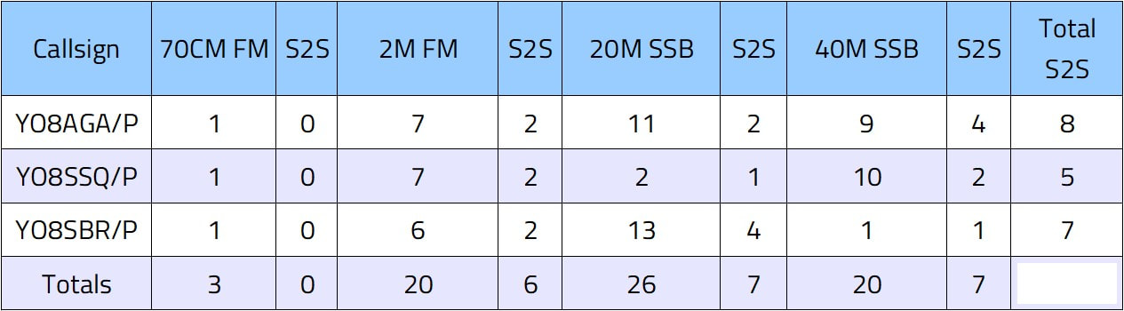 We made QSOs in 70cm, 2m, 20m and 40m. Andrei also managed one PSK31 contact. There was total silence in the 17m band. It was a pretty good day for SOTA, with many summits activated in EU. From YO we could only make contacts with people nearby, on VHF. Operating equipment was Yaesu FT-857D, inverted vee antennas for SSB, power output between 30-45W. In VHF we had a vertical dipole, the power output was set at around 15W (up to 40W when needed). Essential summit info Target summit: 8 pointer YO/EC-065 "Pietrosu" - https://summits.sota.org.uk/summit/YO/EC-065 Our Route: By car: Suceava - Câmpulung Moldovenesc - Pojorâta - Chiril - Zugreni Lodge (and back). On foot: Zugreni Lodge - Bogolinu Peak - Pietrosu Peak - Cojoci - Chiril - Zugreni Lodge (21 km). GPS Track: http://www.wandermap.net/en/route/3639170-zugreni-pb-cojoci/ (download the track by clicking on "Export GPS data"). GSM coverage: Decent. Summit conditions: Exposed, rocky, bushy, no real shade. In 2020 could open at least three repeaters (Suceava, Rarau, Toaca). Trip report Left Suceava at 8 in the morning and picked up Marian on the way. As the traffic was light we've decided to approach Pietrosu from Pojorîta to Chiril (not as planned initially, from Frasin to Chiril via Ostra). Climbing started at 11 at the Zugreni Lodge. The lodge is on an island formed by two of Bistrita's River branches and is currently closed. On the first kilometer the trail poses a few slipping risks, although chains are mounted on the more sketchy parts. Still, careful foot placement and some handwork is required. After we crossed the river the second time (off the island), we've encountered a short rocky climb. Climbing up is fairly easy, even though there is one section with no holds and no rock either, just slippery dirt. Climbing down is another story and I wouldn't advise it unless you know what you're doing. From there onward the trail is safe, but steep. You gain 1 kilometer of altitude in about 4 kilometers of trail. The mountain is forested for the most part, except the top section. Some alpine shrubs tend to block the trail, but this time the trail was cleared recently for some running contest. The vistas at the top are really special - you can see Suhard, Rodnei, Călimani, Ceahlău, Bistriței Mts, Stînișoarei Mts, the Rarău and Giumalău peaks. The river below and the villages are also a very cool sight. Met four tourists on the way up who were descending via our route. We climbed Pietrosu in 4 hours. As many of the local radio hams were out of the area, the activation failed. I only got two valid contacts (YO8BDV and YO8CLN, thank you both for the contacts!). Around 1600 hrs we went down by continuing on the trail away from the starting point for about 1.5 kilometers. Near the top we met another three guys going up - busy day. Then we took a left turn and followed a creek off the mountain. Amazingly, the creek posed no problems and we actually made very good progress walking directly on the bedrock. The 12 kilometer stretch of dirt and tarmac roads that followed killed our feet and is, by far, the most hurtful. Essential Summit Info Target summit: 8 pointer YO/EC-062 "Cearcănu" - https://summits.sota.org.uk/summit/YO/EC-062 Our Route: Maramures County. At Prislop mountain pass/monastery there is a gravel road that takes you north then west on the ridge near Cearcănu peak. The trail is marked by a blue triangle, but you can't rely on it too much as it's quite random. The last kilometer or so is through thick bush of Pinus mugo (bog pine or dwarf mountain pine). GPS Track: http://www.wandermap.net/en/route/3638141-cearcanu-yoec-062-best-option/ (download the track by clicking on "Export GPS data"). GSM coverage: Decent. Summit conditions: Exposed, rocky, bushy, no real shade. Has a wooden pole and cross on the top good for anchoring the antenna. Activity report We wanted to activate Cearcanu ever since we first saw its majestic rock teeth, years ago. We thought of doing it in winter, but sat imagery showed some thick vegetation and some exposed areas as well which seemed hard to tackle in deep snow. A previous bad experience dealing with Pinus mugo (a species of dwarf pine that grows on relatively high altitudes) made us postpone the activation for a couple of years. Finally, we've decided to try it this August. The trail on the GPS sure looked easy enough, with barely any climbing (some 250 meters of vertical climbing which is regarded as piece-of-cake). Some friends were joining us as well. Weather was fine (too hot) and the scenery spectacular. After a two and a half hour drive we started hiking and soon the hot sun of August melted our skin away. I am particularly prone to sunburn and overheating. If I could control the sunburns fairly easy by applying obscene amounts of sunscreen, the heat proved a much tougher adversary. After only 4 kilometers I was exhausted. My head hurt and I felt dizzy. Others were complaining too. We took a break next to an info panel where the trail split in two. The left trail went up to the secondary summit, while the right trail was supposed to lead to Cearcanu itself, but kind of disappeared into the shrubs. It was not marked and it looked really bad. I crawled through a section of Pinus mugo, some 20 meters maybe, and as I couldn't see any improvement in the trail condition I turned back. We decided it was best to climb on the secondary summit and from there, maybe follow the ridge on a hopefully better trail. Nope, not really. No trail and no accessible ridge. At first it looked better, but it turned into horror soon enough. Andrei pushed onward and we stayed behind in hope of good news. The others decided to turn back to the car. Marian and I followed Andrei into and under the waves of green. This shrub, Pinus mugo, is not that widespread in the world and is pretty nice if you don't get to know it up close and personal. Its branches are very flexible and either push you away or snag on you. Going forward through this vegetation is done by a combination of ducking, crawling, pushing, pulling, bending and brushing against the rugged branches. It's exhausting, sometimes even painful. We did this for maybe half an hour before getting on the ridge where things improved a bit. Still there was some shrub to be fought, but nothing as extreme as before. The summit was ours, no doubt. The thought of turning back via the same way seemed to increase my headache, so I decided not to think about it. The lack of shade at the top was pretty nasty, but the view of Rodnei Mountains somewhat compensated for this drawback. We activated the summit in 20m SSB and in digital modes. At around 5 PM we had everything packed and left the top. From our position we could clearly see the path following the contour lines marked from place to place by blue triangles and decided to try it. Except a few minor sections of medium difficulty, this new path was completely superior in every way (less shrubs, less climbing, had markings, overall easier to hike on). The exit (where the trail split and where, on our way up, we decided to go the other way) was the worst part. Once out of the bushes there was nothing else to worry about. The heat and shrubs made this activation pretty harsh and we're not looking to go back there anytime soon. This is probably our third summit that made the list of `summits to not return to', next to Hasmasul Negru YO/EC-070 and Tomnatecu YO/EC-047. Essential Summit Info Target summit: 8 pointer YO/EC-070 "Hășmașul Negru / Fekete Hagymas" - https://summits.sota.org.uk/summit/YO/EC-070 Our Route: We could not find a trail so we improvised. Terrain is pretty bad: fallen trees, steep slopes, rocks and boulders, thick vegetation. GPS Track: www.wandermap.net/en/route/3599544-hasmasul-negru/ (download the track by clicking on "Export GPS data"). GSM coverage: Pretty good on top, bad overall. Summit conditions: Forested with some open spaces. There's a wooden summit marker post on top from which we hung the 40m antenna. Activity report This summit was supposed to be activated in a series of summits in Hasmas Mts., but due to bad weather we decided to abandon the plan and only go for Hasmasul Negru. Friday we've arrived in Lacu Rosu around 9am and were on trail at 9.30am. Our route took us slightly off main course to a sightseeing spot above Lacu Rosu. Weather was great. After a short break we continued to Hasmasul Negru on a trail marked by a blue dot (sometimes a blue circle). Nearing Hasmasul Negru the trail became less obvious and less maintained. We could not find any visible route up to Hasmasul Negru, even though the trail appeared on maps. Our backpacks were too heavy even for our initial 3 day hike, but for this climb alone they were overkill. The climb to Hasmasul Negru summit is short but steep and, lacking a path, advancing is sometimes difficult. Fallen trees, rocks, boulders, shrubs and loose dirt are commonplace. The top itself is not spectacular, as the view is blocked by trees (there's a clearing below summit from which you can see Hasmas Mts. supposedly, but we skipped that part). Didn't encounter any bears, only droppings. The radio activity went unexpectedly smooth thanks to a lively 2m presence. We installed the 40m antenna and the BitX, but the QRN was bad and managed only a few contacts. Around 6pm we started on our way to Poiana Alba camp spot. The trail that follows the contour line of Rotund Mt. on its Eastern slope was blocked by many fallen trees. Once out of the forest we couldn't see any more markings so we had to visually locate the refuge. We had a half an hour of light ahead of us so we weren't too worried. The hut is nicely built and can accommodate 6 people in the bunks, but there's room for maybe 2 more on the floor. There's a water source nearby. The next day (Saturday) we decided to head home. The morning was sprinkled with some vigorous rain showers, but the real rain started around 11 and it kept pouring down for the entire day. Three hours later we reached the car, soaked, cold and tired, shoulders and feet aching from the heavy loads. I think Hasmasul Negru was one of the - if not the - hardest SOTA activation so far (but only because of the heavy backpacks). Essential Summit infoTarget summit: 2 pointer YO/EC-516 "Holm" - https://www.sota.org.uk/Summit/YO/EC-516 Our Route: Our track has a different start/end than the one linked below because the trail simply wasn't there anymore. GPS Track: http://www.wandermap.net/en/route/3591686-tudora-dealul-holm-yoec-516/ (download the track by clicking on "Export GPS data"). GSM coverage: So and so on top, variable overall. Summit conditions: Forested. Steep but short slopes near the summit. Picked up ticks: 1 Activity reportTudora is one of the largest broadleaved forests in the Suceava area. The forest actually shares most of its area between Botosani and Iasi counties, with only a tiny fraction in Suceava. There are some good gravel roads crossing the forest, but the secondary trails can be tricky to navigate on two or four wheels. The mud is of the slippery-sticky type. We've started biking on a trail that soon disappeared into the bushes. In the first kilometer we had to stop several times to clean the mud off the wheels - they simply wouldn't spin anymore. An hour later, when we finally escaped the slow progress through mud, a flat tire struck. Two very sharp thorns produced two small punctures in Andrei's front wheel. The tube was replaced and we carried on, alternating riding and pushing until we got to a grassy plateau which we visited about 4 years earlier on our motorbikes. From there we followed the dirt roads until we reached the lip of the forest on the other side of the clearing. There the road vanished altogether and we stumbled about through the forest, crossed a ravine and then we spotted something that almost looked like a highway. Indeed, there was a gravel road in perfect shape that just started from the middle of a thick forest. We made good progress, most of the remaining ride to the summit being on well maintained gravel roads. Before activating, though, we were chased by some bees. Luckily we escaped their wrath and reached the steep slopes of Holm (which is just a hill, really) unscathed. Andrei went ahead and I stayed behind and chased him from below. I also tried my best to camouflage the bikes so we wouldn't have to carry them up. The slope was too steep for push-bike and we didn't know any alternate routes. After a while I joined Andrei on top and made contacts with our dedicated chasers from the local group who probably had to wait for us quite a while as we started the activation with a two hour delay. I managed one QSO in 7 MHz, then went back to the bikes, slipping on the mud and getting poked in the eye by a tree branch - no serious injury, but I felt some intense temporary pain. We returned on a different road and encountered even worse muddy conditions due to logging and previous rains. After some more cleaning, pushing and sliding, we found ourselves once again on the grassy plateau. From there it was all downhill to the car. The temperature was cool, a bit windy and overcast, perfect for biking in the woods. No rain. A great day in a great area. The ride: 40 kilometers and about 900 meters ascent. Big thanks to our chasers: YO8AZQ, YO8SST, YO8SFF, YO8TLC, YO8TLD, YO8SDE, YO8SJD. Later edit: Andrei discovered a tick on his right leg, above the knee. Removed it without problems. Essential Summit InfoTarget summit: 8 pointer YO/EC-007 "Giumalau" - http://www.sota.org.uk/Summit/YO/EC-007 Our Route: From Saua Fundu Colbului we hiked on the trail marked with a red band. We climbed the last bit (above the treeline) straight up to the ridge instead of going on the summer trail to avoid avalanche prone terrain. Check the GPS track for details. GPS Track: http://www.wandermap.net/en/route/3549630-giumalau-yoec-007/ (download the track by clicking on "Export GPS data"). GSM coverage: Fair. Summit conditions: Open, no cover. There's a huge concrete cross on top and a concrete table. Other info: Medium steepness, can be medium-hard during winters because of snow accumulation. Activity ReportOne year later we returned to Giumalau and it was even more extreme than last time. The winds blasted us and what was supposed to be a clear day turned to complete white-out. At the top there were 60 km/h winds with even more aggressive gusts. At one point I got slapped in the face by something which I thought it was maybe my hood or another piece of loose equipment. I double checked everything and there was absolutely nothing loose that could have hit me. So I concluded I was slapped by a massive gust of wind. 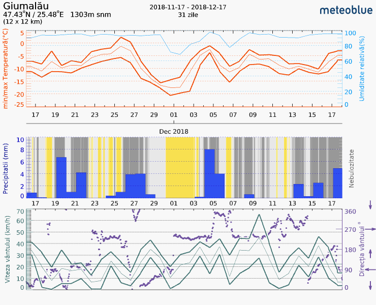 In the bottom panel, wind speed plotted in dark-green. It peaks 9 Dec, exactly in the middle of the day. We were just lucky, I guess. I was recovering from a cold and argued that we should not attempt deploying the short-wave antenna, as it would've taken too long. On such winds it was probably nearly impossible to hold it up, anyway. Thanks to our local chasers we managed to make the QSOs on VHF/UHF. Essential summit infoThe summit is on the northern side of Campulung Moldovenesc, accessible by crossing the Moldova River and climbing on the road to the former Deia cabin. Then it's a continuous climb to the top. Bears are known to live in the area, but so far they didn't cause trouble. GSM signal available, nice views, Bodea, Runc and Magura Rungului are visible across the town to the south. Rarau mt. is visible in the distance, too. Activity reportOn this trip we were accompanied by Marian. In Suceava the weather was pretty dry, yet overcast. In Ilisesti, 25 kilometers away, some sort of blizzard started and it snowed pretty much all the way to Campulung, where Tomnatec is. The first two kilometers or so of climbing were done on a dirt road which at the time was covered in a thick layer of ice, which in turn was hidden under ten centimeters of fresh snow. I slipped and fell on my first step and, as pain surged through my tender ankle, uttered a few words that don't worth mentioning. I then proceeded with extra care, a solid plan considering that I only slipped and fell only twice more. As soon as we've left the icy road, progress was a lot easier, despite the increased gradient. It snowed all the way, but it was really beautiful. At times the sun would come out which made for some dramatic visual effects. On top we've installed the antenna and rig and worked a few stations in 7 MHz, but at -10 degrees Celsius it was fairly cold. The descent was harder, slipping and sliding a lot on the snow covered grass. The thought of walking the last two kilometers on the icy road after dark bugged me a bit, but as soon as we got there I've found out that it wasn't as bad as I expected. Essential summit infoTarget summit: 8 pointer YO/EC-007 "Giumalau" - http://www.sota.org.uk/Summit/YO/EC-007 Our Route: From Saua Fundu Colbului we hiked on the trail marked with a red band. We climbed the last bit (above the treeline) straight up to the ridge instead of going on the summer trail to avoid avalanche prone terrain. Check the GPS track for details. GPS Track: http://www.wandermap.net/en/route/3549630-giumalau-yoec-007/ (download the track by clicking on "Export GPS data"). GSM coverage: Fair. Summit conditions: Open, no cover. There's a huge concrete cross on top and a concrete table. Other info: Medium steepness, can be medium-hard during winters because of snow accumulation. Activity reportWe parked the car in Saua Fundu Colbului, right where the trail starts. It was quite a bit of snow and progress was slower than usual on some stretches. In the alpine zone the original track followed a diagonal trail that climbed on the eastern face, but in winter time there's a more direct route to the ridge, chosen for avalanche safety reasons. The snow was quite deep and the junipers on the ground didn't help either. Still, there were some fresh tracks left by a group of hikers that passed through there earlier, so it wasn't that bad. The milky fog restricted the visibility to about a hundred meters for our entire stay at the top, so the spectacular views of the surrounding mountains and valleys remained concealed. The huge concrete cross that marks the summit was completely covered in ice and snow, a testament of how windy it can get around here. We were lucky, though, having almost no wind during the activation. It was the first summit to activate with the newly acquired & assembled BitX40 transceiver. Because of not having the chance of testing it properly, and being low power, we carried the Yaesu FT857 as backup. The BitX40 worked surprisingly well, however, and we made enough QSOs before freezing up and deciding to pack it in and leave. The descent was quite painful for my leg and I moved slow through the crusty snow. We got to the car after dark. It was probably one of the nicest summits we ever activated. Essential summit infoTarget summit: 6 pointer YO/EC-031 "Seredna" - http://www.sota.org.uk/Summit/YO/EC-031 Our Route: We wanted to activate another summit, but a blocked road made us go to Plan B. Left the car in Demacusa and used the dirt road that goes all the way to the top through some meadows. GPS Track: http://www.wandermap.net/en/route/3549624-seredna-yoec-031/ (download the track by clicking on "Export GPS data"). GSM coverage: Pretty good. Summit conditions: Open, but the treeline is relatively close. Other info: Very easy, but be careful of shepherd's dogs in summer. Activity reportOn this day we were joined by Marian and Magda. We prepared Seredna as a backup summit because there was a high probability of finding the road to Pascani summit closed. And indeed it was. So we climbed Seredna instead. This has to be one of the easiest 6 point summits in our region, nothing more than a walk, with an altitude gain of about 300 meters. It was quite windy, but nice otherwise. Made 23 QSOs between us. |
AuthorHi, we're a team of hams from Romania. We're into SOTA and other activities. Thanks for stopping by! Archives
August 2020
Categories |
 RSS Feed
